
Page 11 - K&A External Newsletter_January2018
P. 11
Kabul DID YOU KNOW?
Kabul is elevated 1,750 m above
sea level, and surrounded by high
mountains.
COUNTRY CLIENT FEATURES
Afghanistan Kabul Municipality Redesign of 7 km
canal length
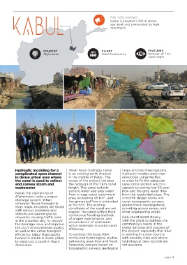
Hydraulic modeling for a Wazir Abad Drainage Canal maps and site investigations.
complicated open channel is an existing earth channel Hydraulic models were then
in dense urban area where in the middle of Kabul. The developed using HecRas,
the canal is used to collect scope of the project includes in order to fix the adequate
and convey storm and the redesign of the 7 km canal canal cross section which is
wastewater length. This canal collects capable to convey the 50-year
Kabul, the capital city of surface water and grey water flow and the grey water flow
from the residential areas. The
from a huge water catchment
Afghanistan, lacks a proper area, exceeding 45 km , and 4-month design works will
2
drainage system. When the generated flow is estimated cover topographic surveys,
rainwater floods through its at 34 m /s. The existing geotechnical investigations,
3
main roads, residents are faced conditions of the canal are not providing access ramps, and
with serious problems and regular; the canal suffers from other engineering works.
vehicles are submerged by continuous flooding and lack
rainwater, causing traffic jams of proper maintenance, and K&A coordinated closely
in the crowded city. To resolve accumulation of sediments with the client to address the
the drainage issue and improve which minimize its section and community’s needs in the
the city’s environmental quality, efficiency. design process and success of
as well as the urban transport the project; especially that K&A
efficiency, Kabul Municipality To address this issue, K&A is working in a new country
turned to Khatib & Alami (K&A) conducted hydrological studies with security risks and where
to construct a canal in Wazir estimating peak-flow and flood hydrological data records are
Abad area. frequency analysis based on not available.
topographic surveys, geological
page 11