|
Amid the unprecedented challenges caused by Covid-19, geospatial technology experts from Khatib & Alami (K&A) have played a key role in helping government agencies to track the spread of the virus with speed and accuracy, enabling evidence-based decision-making.
Through the deployment of geographic information system (GIS) technology, K&A has helped municipalities and health authorities to understand the impact of the disease on their communities.
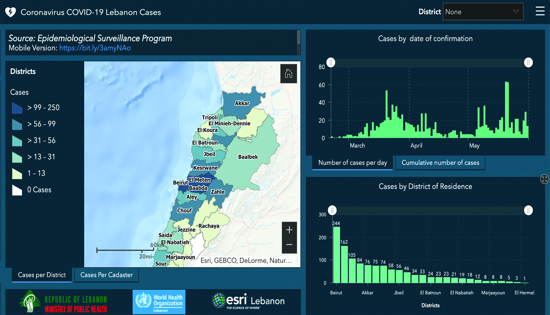
For example, a country-wide web portal was developed for the Ministry of Public Health (MoPH) in Lebanon, with support from ESRI Lebanon and the World Health Organization (WHO). This real-time public dashboard utilizes ESRI’s mapping technology, ArcGIS Dashboard, to help track the progression of the disease at a district and national level.
The data for the dashboard is provided by MoPH, accessible from the ministry’s website, and updated daily through an online portal. As the Covid-19 virus grew into a pandemic in Lebanon, the dashboard became one of the most trusted and reliable sources for tracking the disease.
A map on the dashboard highlights districts where cases have been reported and symbolizes the number of cases. By using a web environment, the map can be rapidly distributed to other authorities or to the general public. Users can pan and zoom around the interactive map to focus on particular areas and districts, and can look up specific detail such as the number of cases by age group or gender.
In addition to the public dashboard, GIS (geographic information system) technology is further utilized to provide real-time forms for the emergency call center. The form was created using ESRI’s Survey123 application to gather information about caller records, symptoms, as well as their location. The call center aggregates, consumes, and analyzes this real-time data to produce a Ministry dashboard that tracks the total calls recorded for Covid-19.
Through technology monitoring and evaluation, MoPH has been able to continuously conduct national preparedness and response procedures, at regular intervals, to help contain the spread of Covid-19 in Lebanon.
Used in this way, GIS technology has been helping health authorities across the world answer key questions such as:
• Which neighborhoods might be affected next?
• Are essential services such as testing clinics located in the right areas?
• Are any key workers, schools or care homes located in high-risk areas?
• Where are vital supplies such as medicines or food most needed?
• Which hospitals are likely to suffer from capacity issues?
GIS can seamlessly integrate virtually any type of data to enable predictive analysis, planning and timely actions. By answering key questions, it has been providing governing bodies across the world with the information they need to understand where and when to place vital resources. This has helped to reduce disruption and, ultimately, save lives.
HELPFUL RESOURCES
• Desktop version Click here
• Mobile Version Click here
• National Response Room Video (Facebook) Click here
• MoPH Lebanon Hotline 1214 (Available 24/7)
|