|
Mohammad Hammoud, Senior Account Manager in K&A’s Geographic Systems Integration team, looks at the transformational role augmented reality (AR) can play in the construction sector
The last decade has seen BIM (Building Information Modelling) and GIS (Geographic Information Systems) become widely adopted tools across the engineering and construction industry. Both enable people, technology, and processes to deliver improvements in project delivery.
While BIM is known as the digital representation of a facility’s physical and functional models, by including information in three dimensions (3D) and integrating information required for architecture, engineering and construction (AEC) projects, GIS looks at the positioning of structures in relation to their surroundings. It is used to manage and analyze spatial data, focusing more on real world modeling.
While the roles of BIM and GIS can be complementary, the AEC industry hasn’t yet widely adopted a method for truly consolidating the power of both technologies.
Why BIM in construction?
Briefly, BIM improves collaboration while reducing errors. For instance, construction documentation can be produced automatically, workflows can be accelerated immensely, and 3D building models can be created and shared, which widens the accessibility of the data and enables non-specialists to engage and edit building designs.
This 3D modelling has brought tremendous improvements to design and construction. It provides freedom to experiment ideas digitally before committing project money. Architects are able to experiment with new materials and push the pragmatic limits of design without risking the physical construction.
Why GIS in Construction?
GIS can link project activities on sites with 3D drawings to provide better visualization of actual construction progress. It is designed to integrate, manage, and analyze spatial and non-spatial information, related to real-world assets, such as buildings and infrastructure. Most, if not all, of new constructions, renovations, real estate management, infrastructure maintenance and environmental plans are based on GIS.
While BIM is best suited to managing data related to the buildings themselves, GIS is more applicable for everything outside and around the buildings. BIM and GIS are therefore very different.
But is there an efficient way to overlap both technologies? And what would the connection look like between the two?
The missing link
Imagine how much simpler it would be if site workers could simply draw a red mark on the spot where a pipe should go; or if they could quickly locate existing underground infrastructure assets (water/electrical pipes, fiber cables) to avoid damaging or obstructing them.
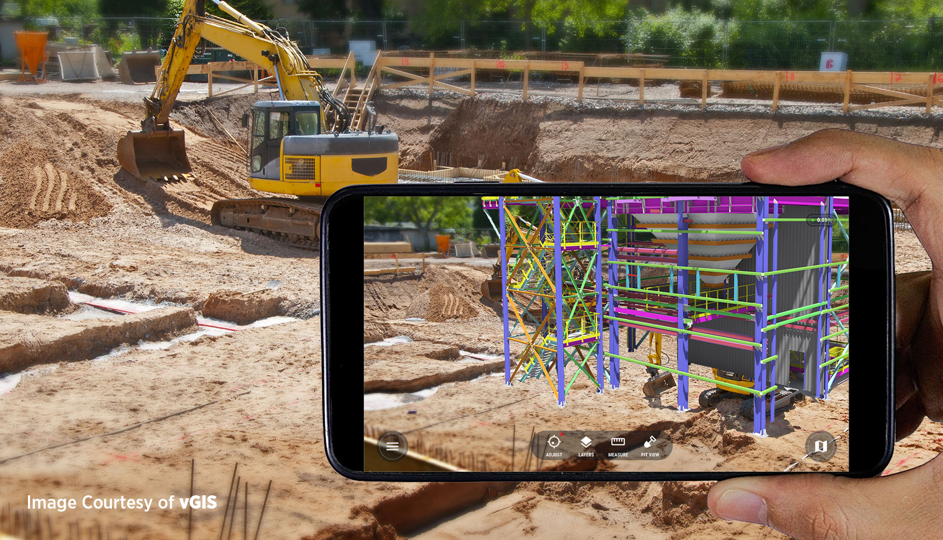
Augmented Reality (AR) has the potential to transform the way people work on construction sites, and could be the “next big thing” in the AEC industry. AR provides a user-friendly means of zooming in and out while looking at BIM and GIS models, making it really easy to observe any mismatches between model and reality. This could provide "the missing link" between BIM models and GIS reality.
AR applications can be used to visualize BIM data, enabling users to introduce any missing objects, correct errors in the model or address the mismatches for further investigation. This will result in many benefits:
• Project Status tracking in Augmented Reality (AR)
A simple status AR tracking app can be deployed, allowing anyone to understand the progress of the project in a visually understandable way. Stakeholders, regardless of their technical expertise, can now access and interact with the project model in real-time, making it easy to follow the project’s progress.
• On-site construction documents
Professionals on the ground can overlay designs in AR on top of the ongoing construction project, as well as surface construction documents from Revit and others software tied to their exact position. Instead of shuffling through thousands of paper-based construction documents or PDFs, the on-site team is armed with the information they need to catch design flaws early and perform their jobs more efficiently.
• On-site clash review
Design and construction data can be combined and visualized into a one-single model. Accordingly, clashes and interference problems can be identified and resolved before construction, while aggregating data from multiple sources. Because AR enables the visualization of BIM and GIS together, an automatic overlay of both the design and real world is now possible.
• Platform as a Vision
Yet the greatest benefit of AR in construction is to integrate all of your BIM and GIS data into an open platform, available to anyone in a truly digital format. Engineers want to know what installations, for example, the electrician has made in a certain time frame. Workers need to receive the information they need for their installation task on site. In addition, users should be able to add feedback to their BIM models on the go, and such AR applications enable this two-way information transfer in real-time.
In summary, construction sites can’t be managed without information – the more readily available that information is, the better it is for all involved with the project. AR is set to bridge the gap between BIM and GIS by bringing together the physical and virtual space onsite.
|